Apollo Expeditions to the Moon
MAPPING AND SITE SELECTION
Meanwhile the third member of the automated lunar exploration team had
already completed its work. The fifth and last Lunar Orbiter had been launched on
August 1, 1967, nearly half a year earlier. When JPL and Hughes began to experience
difficulties with Surveyor development, and with the Centaur in deep trouble, NASA
decided to back up the entire proaram with a different team and different hardware.
The Surveyor Orbiter concept was scrapped, and NASA's Langley Research Center
was directed to plan and carry out a new Lunar Orbiter program, based on the less
risky Atlas-Acena D launch vehicle. Langley prepared the necessary specifications
and Boeing won the job. Boeing's proposed design was beautifully straightforward
except for one feature, the camera. Instead of being all-electronic as were prior space
cameras, the Eastman Kodak camera for the Lunar Orbiter made use of 70-mm film
developed on board the spacecraft and then optically scanned and telemetered to
Earth. Low-speed film had to be used so as not to be fogged by space radiation. This
in turn required the formidable added complexity of image-motion compensation during
the instant of exposure. Theoretically, objects as small as three feet could be seen
from 30 nautical miles above the surface. If all worked well, this system could provide
the quality required for Apollo, but it was tricky, and it barely made it to the launch
pad in time to avoid rescheduling.
| | |
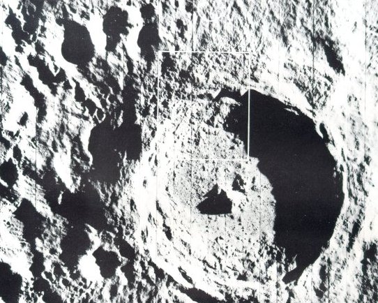
The youngest big crater on the Moon
is Tycho, which is about 53 miles
across and nearly 3 miles deep. These
Orbiter V photographs reveal its intricate structure.
(Area in the rectangle above is pictured in higher
resolution below.) A high central peak
arises from the rough floor, and the
crater wall has extensively slumped.
The comparative scarcity of small
craters within Tycho indicate its relatively
recent origin. Flow features
seen in both pictures could have been
molten lava, volcanic debris, or
fluidized impact-ejected material.
Surveyor VII landed about 18 miles
north of Tycho, in the area indicated
by the white circle above. Enlargements of these pictures show an
abundance of fissures and large fractured blocks, particularly near the
uppermost wall scarp.
|
The Orbiter missions were designed to photograph all possible Apollo landing
sites, to measure meteoroid flux around the Moon, and to determine the lunar gravity
field precisely, from accurate tracking of the spacecraft. Orbiter did all
these things - and more.
As the primary objectives for Apollo program were essentially accomplished
on completion of the third mission, the fourth and fifth missions were devoted largely
to broader, scientific objectives - photography of the entire lunar nearside
during Mission IV and photography of 36 areas of particular scientific interest on the near side
during Mission V. In addition, 99 percent of the far side was photographed in more
detail than Earth-based telescopes had previously photographed the front.
| | |
This breath-taking view was
one of Lunar Orbiter II's most
captivating photographic
achievements. For many people who had only seen an
Earth-based telescopic view
looking down into the crater
Copernicus, this oblique view
suddenly transformed that
static lunar feature into a
dramatic landscape with rolling mountains, sweeping
palisades, and tumbling land-slides. The crater Copernicus
is about 60 miles in diameter,
2 miles deep, with 3000-foot
cliffs. Peaks near the center
of the crater form a mountain
range about 10 miles long
and 2000 feet high. Lunar
Orbiter II recorded this "picture of the year" on
November 28, 1964, from 28.4 miles
above the surface when it
was about 150 miles due
south of the crater.
|
The first Lunar Orbiter spacecraft was launched on August 10, 1966, and photographed
nine primary and seven secondary sites that were candidates for Apollo landings.
The medium-resolution pictures were of good quality, but a malfunction in the
synchronization of the shutter caused loss of the high-resolution frames. In addition,
some views of the far side and oblique views of the Earth and Moon were also taken
(see here).
When we made the suggestion of taking this "Earthrise" picture, Boeing's
project manager, Bob Helberg, reminded NASA that the spacecraft maneuver
required constituted a risk that could jeopardize the company profit, which was tied
to mission success. He then made the gutsy decision to go ahead anyway and we got
this historic photograph.
|
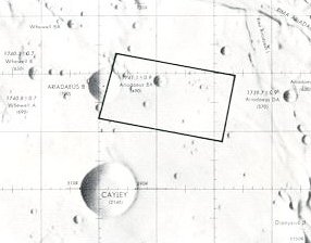
The best maps weren't good enough,
even though they were based an years of
telescopic photography from Earth. In
early planning, the rectangle in the map
at left was a possibility os a landing
site. The handful of craters shown, it
was innocently thought, should be easy
enough to dodge during the last moments
of a piloted landing. The site was an 11- by 20-mile rectangle located
in the highlands west of Mare Tranquillitatis.
|
| | |
The truth about this site was revealed by the accurate
eye of Lunar Orbiter II: it was far too rough
to be attempted in an early manned landing.
In fact, Orbiter pictures showed that parts of the Moon
were as rough as a World War I battlefield, with
craters within craters, and all parts of the surface
tilled and pulverized by a rocky rain. No areas were
found smooth enough to meet the original
Apollo landing-site criteria, but a few approached
it and the presence of a skilled pilot aboard the
LM to perform last-minute corrections mode landings
possible. The high-quality imagery returned
by the Orbiters also returned a harvest of
new scientific information.
|
The next two Lunar Orbiter missions were launched on November 6, 1966, and
February 4, 1967. They provided excellent coverage of all 20 potential Apollo landing
sites, additional coverage of the far side and other lunar
features of scientific interest,
and many oblique views of lunar terrain as it might be seen by an orbiting astronaut.
One of these was a dramatic oblique photograph of the crater Copernicus, which
NASA's Associate Administrator, Dr. Robert C. Seamans, unveiled at a professional
society conference in Boston and which drew a standing ovation and designation as
"picture of the year". Among the possible Apollo sites photographed by Orbiter III
was the landing site of Surveyor I. Careful photographic detective work found the
shining Surveyor and its dark shadow among the myriad craters.
The Apollo site surveys yielded surprises. Some sites that had looked promising
in Earth-based photography were totally unacceptable. No sites were found to be as
free of craters as had been originally specified for Apollo, so the Langley lunar landing
facility was modified to give astronauts practice at crater dodging. Since the basic
Apollo photographic requirements were essentially satisfied by the first three flights,
the last two Orbiters launched on May 4 and August 1, 1967, were
placed in high near-polar
orbits from which they completed coverage of virtually the entire lunar surface.
The other Orbiter experiments were also productive. No unexpected levels of
radiation or meteoroids were found to offer a threat to astronaut safety. Studies of
the Orbiter motion, however, revealed relatively large gravitational variations due to
buried mass concentrations - the phrase was soon telescoped to "mascons" - in the
Moon's interior. This alerted Apollo planners to account properly for mascon perturbations
when calculating precise Apollo trajectories.
With the completion of the Ranger, Surveyor, and Orbiter programs, the job of
automated spacecraft in scouting the way for Apollo was done. Our confidence was high
that few unpleasant surprises would wait our Apollo astronauts on the lunar surface.
The standard now passed from automated machinery to hands of flesh and blood.
THE SELECTION OF APOLLO LANDING SITES
The search for places for astronauts to land began with telescopic
maps and other observations from
the Earth, and Ranger Photos. The
site-selection team considered landing constraints, potentials for
scientific exploration, and options if a
launch was delayed, which shifted
chosen sites to the west. The team
then designated a group of lunar
areas as targets for Surveyors and
Lunar Orbiters.
From the Orbiters' medium-resolution photos, mosaics were made
and searched for geologic and
topographic features that could
make a landing risky: roughness,
hills, escarpments, craters, boulders,
and steep slopes.
Navigation errors could cause an
Apollo landing module to miss a
target point up to 1.5 miles north
or south and 2.5 miles east or west.
So ellipses were drawn an the
mosaics around possible target
areas. Those ellipses represented
50, 90, and 100 percent dispersion
possibilities. The surfaces within
them were then examined to select
the target points that appeared to
be least hazardous.
Flight-path clearance problems
were considered next. This is illustrated by drawing diverging lines
eastward for 35 miles from the
elliptical areas that otherwise looked
best on the mosaics.
| |
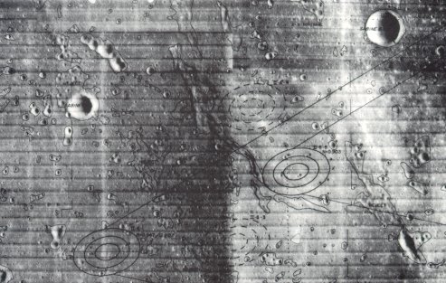
A typical marked mosaic is reproduced above. It is a view of a
region in Mare Tranquillitatis, and
the area within the set of ellipses
at the far left was chosen as the
target for the first manned landing.
Before it was selected, high-resolution Orbiter Photos were used to
examine details within the landing
ellipses. In those Photos surface
irregularities as small as 3 feet
could be seen. One such mosaic is
reproduced below.
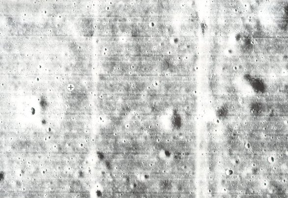
The black cross in a white circle
marks the spot
where the Apollo 11 astronauts'
landing module descended. It was in
an elliptical target area only 200
feet wide.
|
|
|
| | |
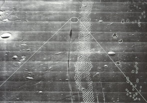
The picture above is an oblique
view of the same area. This Lunar
Orbiter photograph illustrates more
nearly the way it would look to an
astronaut descending to land. The
white lines iridicate the elliptical
target site and the approach boundaries. Processing flaws such as seen
in this picture resulted occasionally
from partial sticking of the moist
bimat film development used
aboard the Orbiter spacecraft.
|
|