
Chapter 3: The Terrae (1/2)
 |
 |
|
|
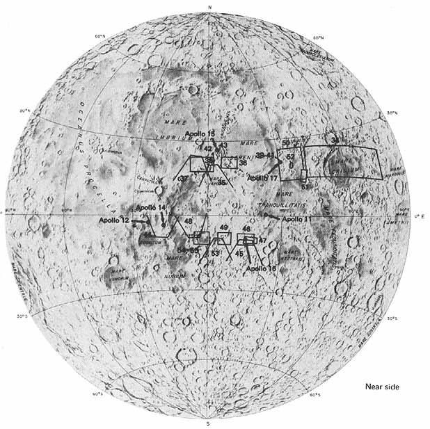
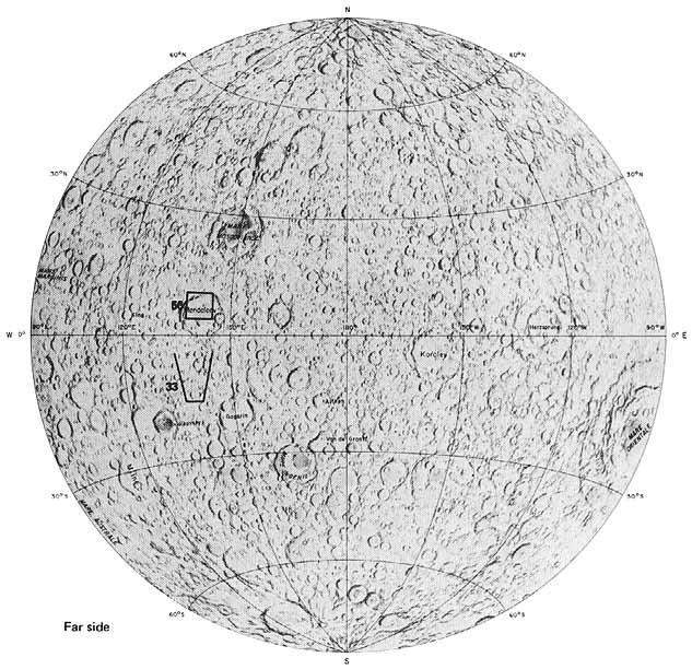
[45] In the first chapter the terrae or highlands were described as the brighter, older, and generally higher standing terrain occupying most of the Moon's surface (fig. 14). Because they are older, the terrae are much more densely populated by large craters than are the maria. Even though the terrae occupy two thirds of the visible or Earth facing hemisphere (and about 85 percent of the entire surface), less was known about them than about the maria. This is so because of their greater age and apparent complexity and partly because only one of the five successful Surveyor spacecraft landed in the terrae.
Our understanding has, however, increased tremendously as a result of the Apollo missions. The last four missions have been especially rewarding in this respect. Analyses of the returned lunar samples, study of data from instruments emplaced on the lunar surface, and remote sensing instruments in the CSM have filled in many of the information gaps, but have also presented new problems.
Radiometric dates obtained on samples of terrae rocks confirm, as was believed earlier, that the terrae are older than the maria. Although the terrae are highly modified, they are composed of rock material that formed very early in the Moon's history by the process of magmatic differentiation. By this process, minerals formed within an igneous melt become segregated according to differences in their physical properties. Lighter materials rise to the top of the magma body by virtue of their lower specific gravity, and, after solidification, form low density rocks. Among the returned lunar samples thought to represent terra materials not completely altered by subsequent events, varieties of gabbroic anorthosite are the most common. This type of rock is composed largely of plagioclase with varying amounts of olivine and pyroxene. Plagioclase is a common mineral on Earth and one of rather low specific gravity.
The preponderance of anorthositic rocks in the lunar highlands is supported by data from Apollo remote sensing instruments. Some of the chemical differences between anorthositic and basaltic rocks could be determined by the X ray fluorescence and gamma ray experiments of Apollos 15 and 16. The X ray fluorescence results show a higher ratio of aluminum to silicon in the terrae than in the maria, corresponding to the known chemical difference between anorthositic and basaltic rocks. Results from the gamma ray spectrometer show that the terrae contain less iron and titanium than do the maria (Metzger et al., 1974). This also is consistent with the chemical compositions of anorthositic versus basaltic rocks.
The lower specific gravity of anorthositic rocks compared to basalts is another characteristic that was measured directly or indirectly by orbital experiments. The S band transponder experiment flown on the [46] last five missions recorded variations in the lunar gravity field along the ground tracks. The results clearly show that the terra materials are less dense than mare materials. Indirect evidence comes from laser altimeters onboard Apollos 15, 16, and 17 that conclusively show that the terra regions are higher in average elevation than the maria. The continuous high resolution profiles of the Moon's surface provided by the electromagnetic sounder experiment on Apollo 17 substantiated the spot elevations recorded by the laser altimeter. The combined results of these three experiments indicate that most of the Moon's crust like most of the Earth's crust-is in isostatic equilibrium. In other words, areas of high elevation are underlain by low density rocks, low standing areas by high density rocks, and differences in elevation across broad areas are the result of differences in density, or specific gravity.
The ancient rock materials of the terrae have been drastically modified by various processes since their formation early in lunar history. Repetitive bombardment by impacting bodies has been the most important cause of modification. Countless impact events have resulted in the widespread redistribution of materials over the surface, the brecciation of the rocks so displaced, and the metamorphism by shock of the minerals that make up the rocks. The impact events have been so numerous and their cumulative effect has been so pervasive that few samples recognizable as original crustal material have been resumed by the Apollo missions.
Other processes that have modified the terrae are tectonism, volcanism, and mass wasting. Tectonism is visible in numerous linear structures transecting the terrae. Some have been recognized and mapped as normal faults, or as pairs of closely spaced normal faults bordering grabens. Some of the largest linear structures are on tile near side, radiating from the edge of the Imbrium basin. They are obviously related to the formation of that basin. However, over the entire Moon, the majority of linear features are oriented in northeast and northwest directions. This arrangement results in a rectilinear gridlike pattern referred to as the "lunar grid" (Strom, 1964). The origin of the lunar grid is unknown. It must have formed at an early stage because parts of it are modified and intersected by patterns of faults and gouges that radiate outward from the circular basins, themselves features of very considerable age.
Volcanism is clearly evident, for example, in the Abulfeda chain of craters extending for more than 200 km southeast from the crater Abulfeda (fig. 45). This chain is closely alined with two crater chains similar in appearance: one is near the crater Ptolemaeus and the other is near Piccolomini. Another area of possible volcanic activity is the Kant plateau, the edge of which was examined by the Apollo 16 astronauts. Both the Ptolemaeus and Kant areas are high and have abnormally high ratios of aluminum to silicon.
Mass wasting has affected the terrae by reducing differences in relief caused by cratering, tectonism, and volcanism. This form of erosion has subdued the inherent ruggedness of the terrae by moving materials from high areas to low areas. The rate of movement ranges from very slow (as by creep) to very rapid (as by avalanching).-H.M.
|
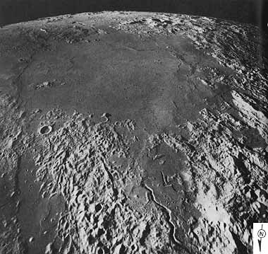
FIGURE 35 [right] .-It is common for the circular form of a very old basin to survive even after all basin materials are obliterated. Mare Vaporum, as shown in this south looking oblique photograph, provides a good example. Its average width is about 200 km. Its circular form marks the outer edge of the ancient, deeply buried Vaporum basin. All the terrae surrounding Mare Vaporum are blanketed by massive ejecta of the Imbrium basin, the center of which lies to the north, behind and to the right of the camera. The ejecta disappears beneath Mare Vaporum. The circularity is enhanced at the left (east) of the picture by a system of mare ridges and scarps that was localized over an old Vaporum basin ring. The cratered, linear Hyginus Rille is near the southern horizon, and the sinuous Conon Rille, to be described later in this book, is in the foreground. D.E.W.
|
 |
[49] FIGURE 36 [above] .-The Haemus Mountains bound the southwestern edge of Mare Serenitatis and form the rim of the Serenitatis basin. They have a strongly lineated pattern that is most apparent in the lower left part of this stereoscopic view. (The width of the stereogram within this mosaic is shown by the bar across the bottom.) The trend of the linear pattern is radial to the Imbrium basin, the margin of which is about 250 km to the northwest of the edge of the picture. Carr (1966) described the mountains as composed mostly of ejecta from the Imbrium basin. The lineation may be due to shattering of the lunar crust by the Imbrium impact event, depositional fluting of the ejecta, gouges made by impacting debris from the Imbrium basin, or a combination of the three.
The prominent rilles in the upper part of the stereogram are grabens or fault troughs transecting both terra and mare surfaces. They are roughly concentric to the edge of the Serenitatis basin. The rilles become less distinct in the terrae, attesting to the easy destruction of surface features in terra material by mass wasting. Within Mare Serenitatis the rilles are partly flooded by the younger lavas that have filled the basin. A dark mantling material, named Sulpicius Gallus Formation, covers parts of the highland and mare surfaces alike. In the highlands the dark material has been removed from the tops of hills and steep slopes and reveals the underlying bright highland material. The dark mantle is conspicuous in the right center of the stereogram near the small kidney shaped crater (arrow). In this same crater and in small, young, rayed craters nearby, the Apollo 17 astronauts observed orange material. This suggests that the dark material here is similar to that sampled at the Apollo 17 landing site on the other side of the basin where orange material was found on the rim of a young crater.-B.K.L.
|
|
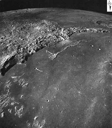
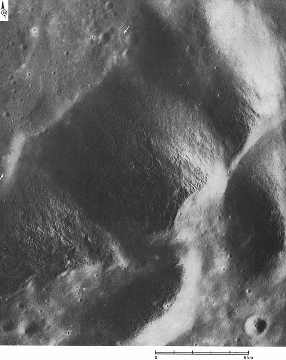
[50] FIGURE 37 [left] .-An oblique view of the southeastern part of the Imbrium basin, one of the largest multiringed, circular basins on the Moon. Most scientists agree that it was formed by the impact of an asteroid, comet, or other planetary body striking the lunar surface at hypersonic velocity. The Imbrium event excavated a depression nearly 1300 km in diameter in the terrae, uplifted and intensely deformed the adjacent terrae, and blanketed much of the lunar surface with debris ejected from the depression. The depressed area was subsequently flooded by lava flows to form the dark relatively smooth surface recognized as Mare Imbrium. The Montes Apenninus form the southeastern rim of the basin. They and other rugged areas of light material visible here are ancient terrae uplifted by the impact event and covered to varying thicknesses by ejecta debris. Material from the Apennine Mountains was collected by the Apollo 15 astronauts who landed near the foot of the mountains not far to the left and below (that is, to the northeast of) the area shown here. The arcuate trends parallel to the margin of the Imbrium basin are mostly faults associated with the formation of the basin. The numbers are explained in the caption for figure 38.-M.W. |
|
| |
|
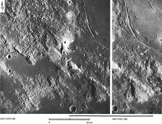
FIGURE 38 [right] .-This mosaic of vertical frames covers part of the same area shown in the preceding oblique view (fig. 37), but shows the Montes Apenninus in much more detail. So that the two pictures can be oriented and compared, the same two craters have been identified in each picture by numbers. The bulk of the mountain chain consists of giant blocks of lunar crust that were lifted and tilted outward by the impact that formed the Imbrium basin. These blocks have been covered by an unknown thickness of debris ejected from the basin. The hummocky deposits (H) probably were formed by the base surge a turbulent cloud of fluidized debris that moved outward along the surface from the point of impact. The hummocks resemble huge dunes. Their dimensions indicate a velocity of flow in excess of 100 km/hr and a maximum thickness of the deposits of several kilometers. The Imbrium event is believed to have occurred 3.95 billion years ago. Later the basin was almost completely filled by successive flows of basaltic mare material. The same material also inundated parts of the outer edge of the Apennine Mountain chain, as in the lower right corner of the picture.-H.M.
|
 |
|
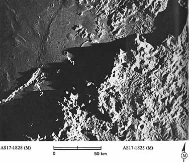
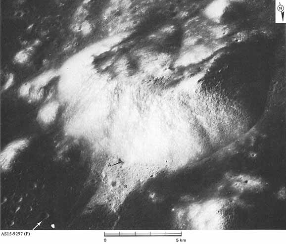
[51] FIGURE 39 [right] .-This mountain mass, called South Massif, on the southeastern rim of the Serenitatis basin towers 2000 m above the Apollo 17 landing site at the bottom left of the picture (arrow). The mountain is typical of the massifs forming the main rim of multiringed basins. Most lunar geologists believe that the massifs are individual fault blocks uplifted as a result of the impact event that created the basin. South Massif is composed of highly brecciated rock that was probably emplaced as ejecta from the Serenitatis basin, although similar brecciated ejecta from other more ancient and more distant basins may be present. Rocky outcrops on the top right of the mountain have shed clearly visible boulders and blocks, but most of the slopes are formed of finer mass wasted debris. Some of this debris has partially filled a small crater at the base of the mountain near the center of the picture (A). An avalanche of unconsolidated surficial material propelled by secondary impact slid off the mountainside and splayed out over the mare surface leaving a thin blanket of light colored breccia on the valley floor (B). The Apollo 17 astronauts traveled across the slide to the base of the mountain.-B.K.L. |
 |
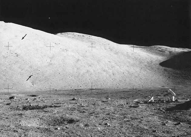
[52-53] FIGURE 40 [above] .-Across the valley of Taurus Littrow from South Massif (from fig. 39) is another big mountain known as North Massif. In this scene of North Massif, an astronaut is kneeling at right. The path traced by a big boulder rolling down North Massif is indicated by arrows. This track is large enough to be visible but just barely-in some panoramic camera frames taken from orbit at an altitude of slightly more than 100 km. On both North and South Massifs boulder tracks such as this one were used by geologists as markers to find the original positions of boulders that were sampled by the astronauts.-K.A.H.
|
|
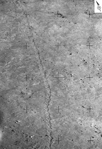
FIGURE 41 [left] .-This is a closeup view of part of the boulder track shown in figure 40. The track is about 10 m wide and the boulder that made the track is about 18 m in diameter (Mitchell et al., 1973). The cause of movement, other than the obvious effect of gravity, is uncertain. Various investigators have suggested that movement was initiated by seismic vibrations of internal origin, vibrations caused by repeated impact events, cyclic thermal expansion and contraction, and instability as soil accumulates above the boulder or is removed from below it. It is also possible that some tracks are formed by projectiles, presumably from impact craters, that skid or bounce along the surface before coming to rest. From detailed studies of boulder tracks, some properties related to the strength, density, and thickness of the lunar soil can be measured.-G.W.C. |
[54-55] FIGURE 42 [above]
.-One of the high, steep peaks of the Apennine Mountains, the highest
part of the Imbrium basin rim. Lighting is from the east (right).
Lunar peaks are normally thickly mantled by their own debris; and
most of this peak is mantled, but some outcrops of bedrock are also
visible. These include ledges along the ridge top in the center of
the picture and, probably, protrusions trending diagonally down the
slopes. The fine lineations trending directly downslope are probably
tricks of lighting produced by the grazing Sun illumination and not,
as was believed during the Apollo 15 mission, edges of strata. Debris
from the slopes has accumulated in a smooth convex upward band all
along the base of the mountains but is most noticeable in the area
between the two arrows. The photographed area is about 14 km
wide.-D.E.W.
Next