
The Spaceport's Impact on the Local Communities
During the years that Merritt Island changed from citrus groves, sand bars, and swamps to a major launch site, the local communities reflected dramatic growth. The area had no major city like Houston; further, no one community dominated the Cape area as Huntsville did the environs of Marshall. Instead, the newcomers dispersed over a wide area.
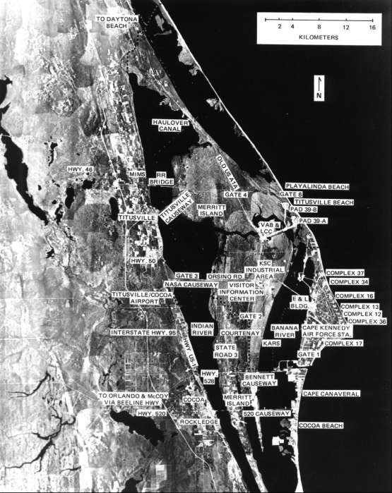
Aerial mosaic of Cape Canaveral and vicinity, April 1967.
A short distance south of Cape Canaveral, Cocoa Beach early assumed a central role in the space program. Many industrial contractors located there. Numerous motels and an excellent beach imparted a holiday atmosphere and made the town popular with tourists. The area's night life centered there. The nation came to identify the space program with Cocoa Beach rather than with other communities in the vicinity. Time magazine carried a lurid activities at Cocoa Beach night clubs on weekends and especially at launchings and splashdowns.33 Cocoa Beach, however, had no television station - there was none in Brevard County. As a result, the cities of Orlando and Daytona Beach influenced the region through their television facilities, even though they were 64 and 80 kilometers distant, respectively.
In 1963 NASA funded three studies of the social and economic development of the area. A regional planning commission looked at roads and water systems, a Florida State University team dealt with community affairs, and a University of Florida research group studied population and economics. The study groups were to finish their reports within two years. The three principal investigators met profitably with NASA's local officials and delegates of NASA headquarters. They further got in touch with representatives of the various Brevard County communities. Florida State University set up an urban research center in the area and published materials developed by the three studies.34
Between 1950 and 1960, the population of Brevard County, 106 kilometers long and 32 kilometers wide, had grown faster than any other county in the country - from 23,653 to 111,435 - an increase of 371%, in contrast to the 79% increase for the state of Florida and 19% for the entire nation. Most of the people settled in four towns: Titusville, the county seat, in the north, Cocoa in the center, Eau Gallie and Melbourne in the south. Titusville reached only half the population of each of the other three in the 1960 census.35
In 1950 Brevard County's 13 schools had an average daily attendance of 4,163; by the school year 1963-64 there were 46 schools with an average daily attendance of 39,873. Classrooms grew from 117 to 1,473 in the 14-year period.36
An infinitesimal percentage of the residents of the four main communities of Brevard County had been born there. Roughly one-fourth of the newcomers came from each of these categories: villages of less than 5,000, towns between 5,000 and 25,000, cities of 25,000 to 100,000, and cities over 100,000. Industrial firms transferred 13% of the newcomers from plants in other areas; 25% freely accepted Florida jobs with a firm they already worked for; and slightly over 25% sought better economic opportunities by coming to the area on their own to seek employment. Some 35-40% came from southern states other than Florida; close to 20% from other counties of Florida; and 15-20% from both the northwest and the midwest. Thus over half were southerners.37
In community involvement, the churches and PTAs led the way. Recreational and hobby clubs grew faster than economic and service-related institutions. Not surprisingly, women tended to involve themselves more in community participation than men. Melbourne, Cocoa, and Cocoa Beach developed active theatre and musical groups, including the Brevard Light Opera Association in Melbourne and the Brevard Civic Symphony in Cocoa. The Surfside Players at Cocoa Beach presented six plays a year.38 Recreationally, Titusville suffered in a way the more southerly areas did not. Its nearest beach, the rough but challenging Playalinda, was so close to the new launching pads that it would remain closed during many months each year.
A Florida State University survey showed slight participation of the newcomers in the political activities of the community or even of the nation. While only 23% of the old-timers, for instance, had failed to vote in the 1960 presidential election, 43% of the early migrants and 52% of the most recent arrivals did not go to the polls.39 Registration requirements naturally influenced voting patterns. The newcomers, in general, willingly lent a hand in such activities as the United Fund; but they did not in any noticeable degree seek political control within the community. The few who did hold office often found older residents suspicious and uncooperative. The main loyalty of the newcomers lay with the space program, with their particular firm, and sometimes with a particular project of that firm, so that many did not feel Brevard County their permanent home, but merely a temporary assignment, as a soldier might look at a tour of duty.
The 1960 census gave Brevard County 111,435 residents. In May 1963, the Florida Power and Light Company estimated the booming population at 156,688. In the estimates for three years after that, the company expected the 72,650 people in southern Brevard County to admit over 52,000 newcomers; the 54,940 in central Brevard to grow to 100,000; and the 25,760 in northern areas at least to double.40
A month later (June 1963) Paul Siebeneichen and his staff at KSC's Community Development Office presented more detailed statistics on the population of the county. By that time, 42 new residents were arriving every day. Nine out of 10 homes were single-family units, and each housed an average of 3.4 people - the statistic the Florida Power and Light Company had used the previous month. The number of men approximated the number of women. Three out of every four men over 14 were married. More than one-third of the women over 13 had jobs. The median income per family was $6,123 - far and away the highest in the state. Consistent with this, the median value of homes was $13,000, compared to the state's average of $11,800.41
In May 1964, NASA and the Air Force took a residential survey by questionnaire of more than 28,000 military, civil service, and contractor employees in the area. This study, tabulated by a team from Florida State University, showed that up to that time residents tended to remain where they had located in the late 1950s. South Brevard had 42.1% of the population, with 20.8% on the mainland and 21.3% in the beach areas. Central Brevard had 40.4%, with 12.7% on the mainland, 15.6% on the north beach area, and 12.1% on Merritt Island. North Brevard (the general area of Titusville) had 12.4%. Orange County had 2.4%; Volusia 1.6%.42
As the population of the area continued to grow, the automobile remained the only significant means of local transportation. Two roads that figured prominently in KSC plans were the north-south Merritt Island road (U.S. A1A ) and the Orsino Road, an east-west street that deadended near the Indian River. The industrial area was southeast of the junction of these two roads. KSC improved the Merritt Island road as the main north-south artery within NASA property. A four-lane divided highway extended from 1.7 kilometers south of the industrial area to the Titusville Beach road, about 8 kilometers north of the assembly building. Studies by the Joint Community Impact-Coordinating Committee, which antedated the Regional Planning Commission, gave no indication of the tremendous growth ahead for the residential area on Merritt Island, about 16 kilometers south of the KSC industrial area.43 As a result, the State of Florida did not widen the two-lane road (Florida Highway 3) that ran south from the KSC area through Courtenay to the Bennett toll road (Highway 528). After 1964, four FHA-backed apartment complexes were to spur extensive residential growth in that area of Merritt Island. As a result, Florida Highway 3 became a bottleneck during peak traffic hours.
East-west traffic was never to present a problem. The four-lane divided highway (the old Orsino road), a few blocks north of the industrial area, ran east a kilometer, then turned southeastward to a two-lane causeway over the Banana River to the Air Force Missile Test Center industrial area on the Cape; there it connected with the four-lane traffic artery to the Cocoa Beach area and south. The building of a five- kilometer long, four-lane causeway across the Indian River to the west connected the Orsino road with U.S. Highway 1 on the mainland a few kilometers south of Titusville. Originally intended as a limited-access road for KSC-badged personnel only, this road became a public highway a few years later with the opening of the Visitors Information Center several kilometers west of the KSC industrial area. On the west, beyond U.S. Highway 1 on the mainland, state road-builders were ultimately to continue the east-west road as a four-lane divided highway just north of Ti-Co Airport to its junction with Florida 50 near the intersection of Interstate 95. Thus traffic could move rapidly west from the industrial area across the Indian River and on to Titusville to the north, Cocoa, Rockledge, Eau Gallie, and Melbourne to the south, and the suburbs of Orlando to the west.
While the national government took steps during this period to increase the opportunities for employment of members of minority races, aerospace employers had few openings for blacks. Black engineers were few. Black applicants in other categories of work often lacked the necessary background, training, or union membership. Thus while the white community multiplied, the black population of Brevard County remained the same, declining noticeably as a percentage - from 25% in 1950 to 11% in 1960.44
KSC and many contractors tried to improve the situation. An Equal Employment Opportunity meeting of 21 April 1964, with most contractors represented, planned a program to draw on the local black population rather than recruit from outside sources. The meeting set up two committees: one for job development and employment, the other for education and youth incentive. There was an obvious need to develop jobs suitable to available blacks, and to include in the local high school curriculum such courses as shorthand, typing, and the like. A month later NASA representatives attended a luncheon meeting sponsored by the contractors' Equal Employment Opportunity committee. That organization set up a program for employing local black teachers during summer vacation to give them first-hand knowledge of the academic skills necessary for employment at the space center, so that they could better counsel their students. Principals of three local black high schools, a representative of the National Association for the Advancement of Colored People, and an Air Force Equal Employment Opportunity coordinator attended this meeting.45
Harry W. Smith, Chief of KSC's Recruitment and Placement Branch, attended a meeting on 30 March 1965 of Governor Claude Kirk of Florida, his cabinet, and black leaders of the State. Smith participated at the request of the black leaders and explained KSC's Equal Employment Opportunity Program. The black leaders commented favorably on the program and hoped that the State government would adopt at least a part of it.46
In order to give wives and children a better understanding of the activities of their husbands and fathers, Kennedy Space Center's Protocol Office began to hold Saturday tours of Merritt Island and launch complexes 34 and 39. The Air Force had begun such a program in 1963 and KSC followed in the summer of 1964. On each of the first two Saturday trips, more than 200 wives and children made the trip.47
By late 1964 other visitors besides the families of employees wanted to see the growing wonders of Merritt Island. As a result, on the first Sunday of 1965, KSC began a Sunday tour. Guards handed out brochures and a letter of welcome from Director Debus as the cars passed through the gate. More than 1,900 visitors came the first Sunday, some from as far away as Nebraska and Ontario. As the Sunday tours grew more popular, KSC laid plans for a permanent Visitors Information Center. In late June 1965, a group of architects met with Debus and other KSC officials to discuss design possibilities, while the National Park Service estimated the potential visitor attendance by 1967 to be in the millions.48
| Next |