
Note on Photography
Photography played a major role in the experimental documentation and study of the earth's surface as called for by the Earth Observations and Photography Experiment (MA-136). Unfortunately, the quality of the earth-looking photography was considerably below that of the photography obtained on previous manned space flights. Of the 1916 earth-looking photographs, 39 percent were considered good photographs. Of the remaining, about 29 percent were overexposed, 21 percent were out of focus, 5 percent were underexposed, and 6 percent had other deficiencies.
Two distinctly different Hasselblad 500 EL 70-millimeter cameras were used. One had a built-in precision 1-centimeter reseau grid and used either a 60- or 100-millimeter lens. Its main use was with the observations experiment. The other Hasselblad was used with either an 80-or 250-millimeter lens, retaining the capability of single lens reflex operation. The films used included Kodak Ektachrome High Definition Aerial Type SO-242, Kodak Ektachrome MS Type QX-807, and Kodak Ektachrome Infrared Aerochrome Type 2443.
Photography of Soyuz 19 at rendezvous was accomplished using the Hasselblad Model 500 EL 70-millimeter reflex camera. Since the actual docking would have been difficult to record using hand-held equipment, the data acquisition camera (DAC), a 16-millimeter variable frame rate motion-picture camera, was employed.
Interior photography was taken with a Nikon 35-millimeter single lens reflex camera with a 35-millimeter lens, a Honeywell electronic flash, and Kodak Ektachrome EF Type SO-168 film. The Nikon was also used with a 300-millimeter lens for earth-looking purposes. Image motion from a handheld camera taking photographs from a vehicle moving at nearly 8 kilometers per second usually results in a degraded photograph.
The selection of earth-looking photographs in this section shows a number of examples of the diverse subject matter available on our little planet. This information and the photographs and captions were made available by Richard W. Underwood, Technical Assistant to the Chief, Photographic Technology Division, Johnson Space Center.
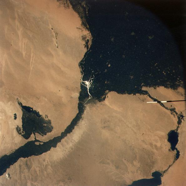 |
Sun glitter highlights the division of the Nile into the western Rashud (Rosetta) and eastern Dumyat (Damietta) branches, which formed the great triangular delta fanning out to the Mediterranean Sea. In the lower left the valley of the Nile is quite narrow (10 to 20 kilometers) and entirely under cultivation. At lower left center the blue-green El Faiyum Depression is similarly cultivated. The lake is about 40 meters below sea level. In the lower right the Suez Canal can be seen from Suez northward past the Bitter Lakes to Ismailiya. 19 July 1975. (AST-9-556) |
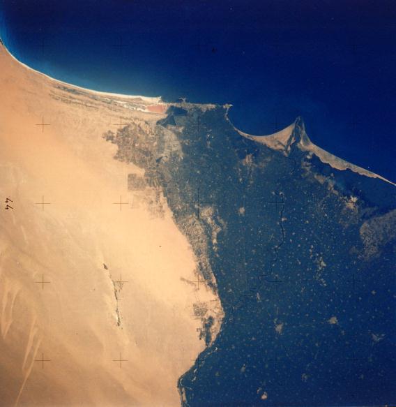 |
Egypt's second city Alexandria is located in the upper center coast to the left of the curved bay, which was the site of the Battle of the Nile. The Rosetta Nile can be traced from the lower center to its mouth. The buff-color Western Desert shows areas of reclamation under development. The thin dark area in the lower center left is Wadi el Natrun, a series of ten salt lakes below sea level. 20 July 1975. (AST-16-1257) |
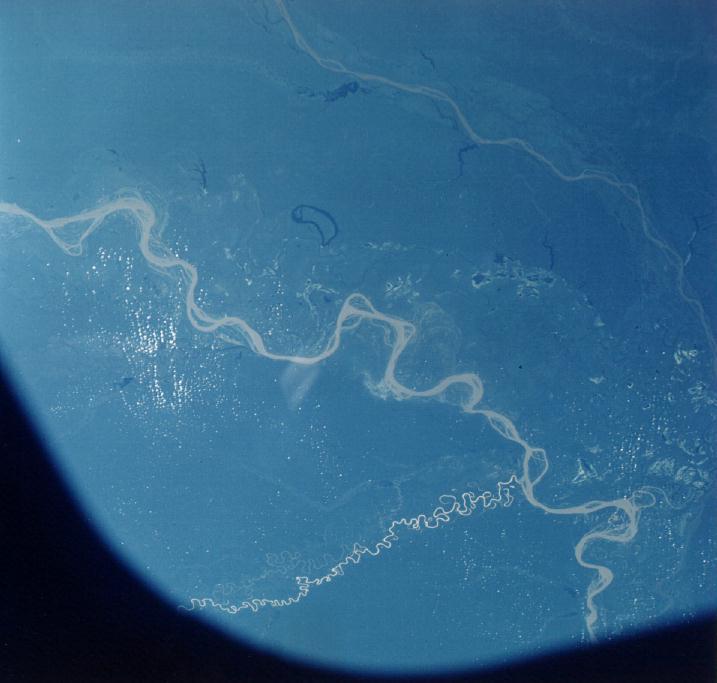 |
The silt-laden Amazon River meanders across the Amazon Basin of Brazil. The much straighter Rio Japura is to the upper right. The smaller Jurura comes into the Amazon from the lower left. 22 July 1975. (AST-21-1682) |
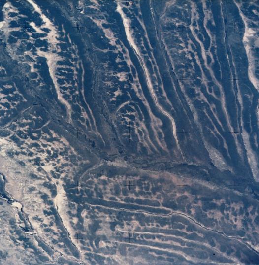 |
A most unique land form and drainage pattern is seen in the area of Angola known as Moxico and Cuando Cubango. The Cuando River crosses the photograph from upper left to lower right. The rivers flow southeast in straight parallel valleys 10 to 30 kilometers apart. South of the Cuando River, they flow parallel and straight east but 5 to 10 kilometers apart. In the lower left part the Cuito River system is seen. 18 July 1975. (AST14-890) |
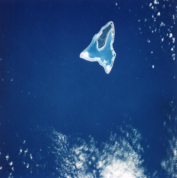 |
Aitutaki Atoll in the Cook Islands clearly shows the contrast between the deep Pacific Ocean, the barrier reef, the lagoon, and the tree- covered main island. Aitutaki is about 1,300 kilometers south-east of Samoa 16 July 1975. (AST-1-39) |
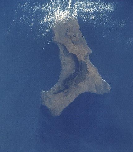 |
The island of Heirro in the Canary group is some 400 kilometers west of the Atlantic coast of Morocco. At one time this volcanic island was much larger. Half the old crater at left center is still seen but at some time in the distant past a massive eruption destroyed the other half of the island, crater and all. 22 July 1975. (AST-23-1939) |
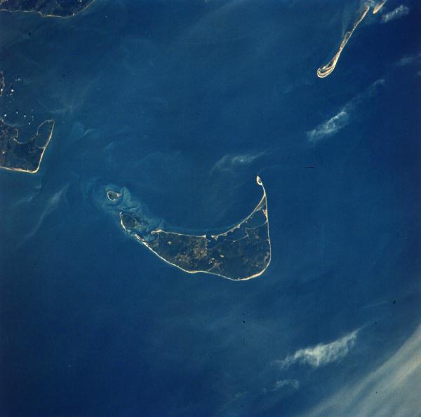 |
Nantucket Island, Massachusetts, is at the center of the photograph. At the upper right, a long sandy point, Monomoy, extends southward from Cape Cod. At the left center is Chappaquiddick Island and part of Martha's Vineyard. These islands represent the remnants of the terminal moraine of the great continental glaciers of the past. 23 July 1975. (AST-1-63) |
 |
In Chile, snow-covered Andean peaks penetrate the lower level clouds to make a striking photograph. The mountains seen are south of Santiago. (AST-23-1908) |
 |
Washington's Cascade Mountains are still snow covered in late July. In the lower left, Interstate 90 passes Cle Elum, Kachess, and Keechelus Lakes and loops over Snoqualmie Pass. The Stevens Pass Highway and Cascade Tunnel are in the upper right. Areas of controversial timber "clear cutting" are easily delineated. 20 July 1975. (AST-30-2601) |
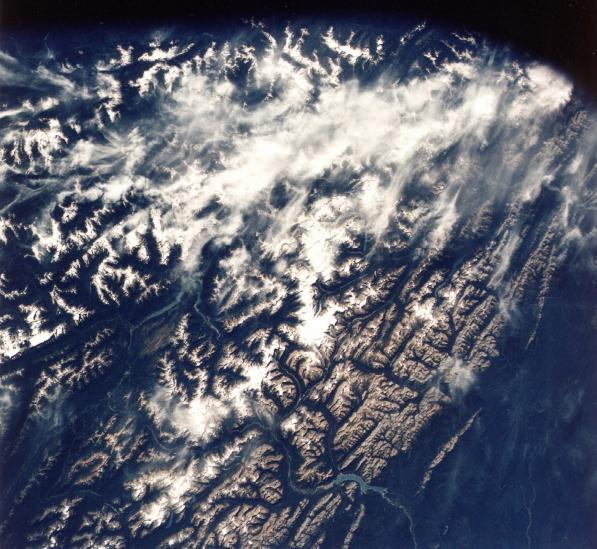 |
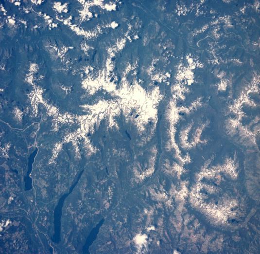
The Canadian Rockies of British Columbia and Alberta show extensive snow fields and glaciers in the area of Banff, Jasper, and Glacier (Canada) National Parks. The North Saskatchewan River is in the lower center. The Columbia River is to the left. Mount Columbia - Alberta's highest - the Athabasca Glacier, and the Clemenceau Icefield are clearly seen near the center. 23 July 1975. (AST-19-1570) |
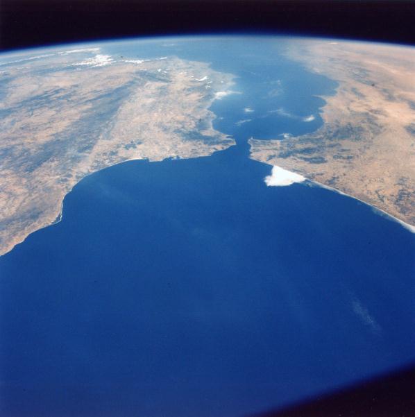 |
The astronaut's view of the approach to Gibraltar is well demonstrated in this photograph. Spain and Portugal are to the left. Morocco and Algeria are to the right. The Mediterranean Sea is in the background. 20 July 1975. (AST- 27-2363) |
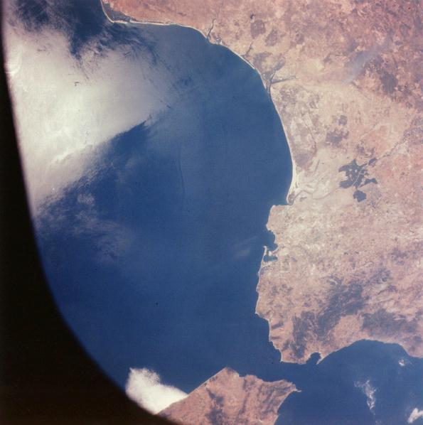 |
An excellent vertical view of the Strait of Gibraltar was made about 1 minute after AST-27-2363. Morocco and Tangier are at the lower center. Spain and Cadiz are to the right. The Huelva-Palos area, Columbus' point of departure for the new world, is at the upper center. A small portion of Portugal is along the upper edge. Cape Trafalgar, the location of the great sea battle, guards the Atlantic side of the important strait. 20 July 1975. (AST-27-2366) |
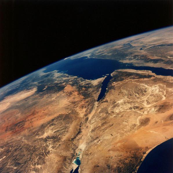 |
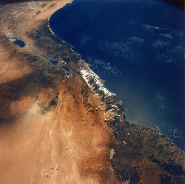
A unique view looking south at portions of Israel (lower center), Saudi Arabia (upper left), Egypt (upper right), and Jordan (lower left) clearly shows the great rifts that have developed into the Red Sea, Gulf of Suez, Gulf of Aqaba, and Dead Sea (lower center). The fertile Nile Valley is clearly traced in the upper right, Sinai is at the lower right, and the harsh deserts of the Al Hijaz are to the left. One can trace a portion of the ancient pilgrim route of the followers of Muhammad to Al Madinah and Mecca from the Levant. 19 July 1975. (AST-9-560) |
 |
A very striking view to the southwest of the Levant. Visible is all of Lebanon and portions of Syria, Jordan, Egypt, and Israel. Notable coastal places from lower right to upper left include Latakia, Tripoli, Beirut, Tyre, Haifa, Tel-Aviv, and Gaza. In the interior, one can locate such places of importance as Damascus, the Sea of Galilee, the Jordan River, Nazareth, Amman, Jerusalem, the Dead Sea, and Beersheba. 19 July 1975. (AST-9-564) |
 |
The giant swing-arm irrigation systems common to the American desert invade the Sahara at Libya's Al Kufra Oasis (lower center). It is said that the water removed here fell to the earth in this massive basin many thousands of years ago. 20 July 1975. (AST-16-1244) |
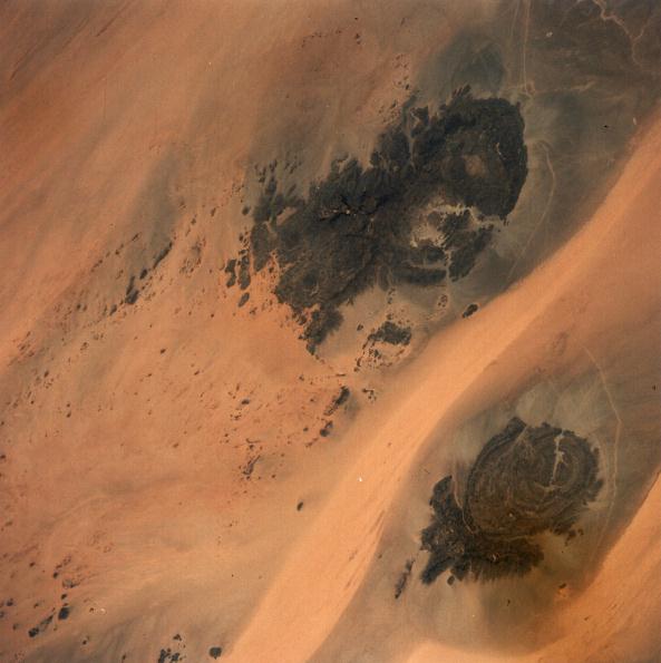 |
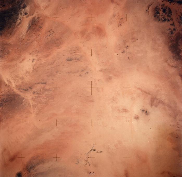
The area shown is where Libya, Egypt, and Sudan join in the east central Sahara. The circular dark basaltic intrusions are Jebel Uweinat (upper r{jebel Arkenu (lower right). The harsh Sahara winds move sand along paths that resemble rivers. 20 July 1975. (AST-2-130) |
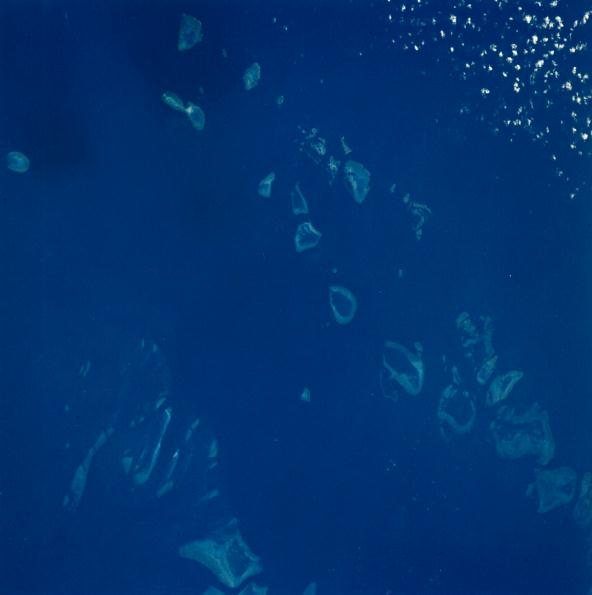 |
East of Queensland, Australia, the Great Barrier Reef extends for over 2,000 kilometers. The bottom detail and reefs in the area known as the Cumberland Islands are clearly seen. 20 July 1975. (AST-2-104) |
 |
The sun glint reflecting off the Coral Sea east of Queensland, Australia, produces a unique effect along a portion of the Great Barrier Reef in the area of Capricorn Channel and Northumberland Islands. Sun glitter will accentuate the visibility of the surface state and the surface current situation. This is in complete contrast to AST-2-104, taken 70 hours later without sun glitter, which clearly shows subsurface detail. 17 July 1975. (AST-1-46) |
 |
Usually Lake Eyre North is seen from space as a large white salt pan in South Australia's Lake Eyre Basin. The very rare, very heavy rains of 1973 and 1974 created a lake 70 by 120 kilometers in size and some 10 meters below sea level. North is to the upper left. 23 July 1975. (AST-21-1726) |
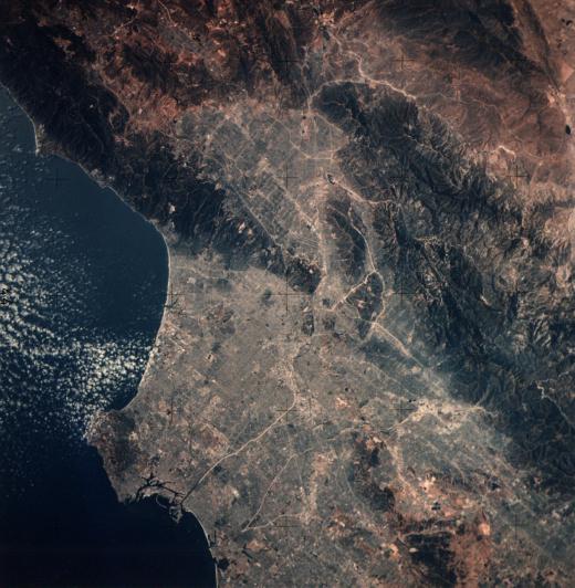 |
A large portion of the Los Angeles Basin is clearly seen in the lower portion of the photograph. The San Fernando Valley is at the upper center. The San Gabriel Mountains cross from upper center to lower right. The light lines that crisscross the photograph are in some cases freeways and in others paved rivers. The Pacific Coast is seen from Point Dume southward to Seal Beach. 16 July 1975. (AST-14-881) |
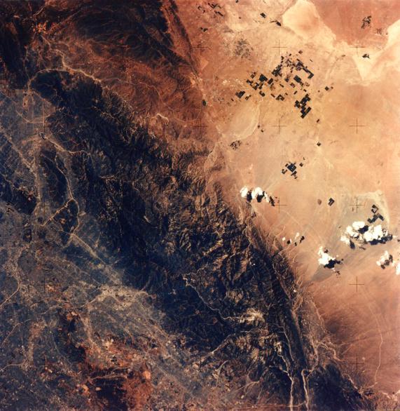 |
A portion of the Los Angeles urban complex is seen in the left and lower portion of the photograph. The San Gabriel Mountains cross from the upper left corner to the lower right. The very active San Andreas Fault can be clearly traced as a straight line from the upper center edge to the lower right edge. The high San Gabriel Mountains block moisture reaching the Mojave Desert (right side), where irrigated fields clearly stand out. The dark fan at the right center is the result of a massive mud slide that originated near Wrightwood. 16 July 1975. (AST-14-882) |
| Next |