
Chapter 6: Rimae (1/3)
 |
|
|
Sinuous Rimae
[179] The sinuous valleys on the Moon (called sinuous rimae or rilles) have been the focus of much debate. The most extreme view is that they were cut by flowing water. However, study of the details of their shape and the nearly complete lack of water in returned lunar samples make this hypothesis very unlikely. Two other possible hypotheses are that they were formed by faulting and subsidence of the lunar crust and that they are lava channels or collapsed lava tubes. The wide variety in shapes suggests that both of the latter processes have been involved. Some sinuous rilles seem to represent almost pure fault troughs while others represent valleys that were formed by flowing lava and modified by filling of slump materials from the walls.
Data obtained by the Apollo 15 astronauts when they landed beside Hadley Rille indicate that layered basaltic lava flows are exposed in the walls of the valley. These rocks may be the only ones sampled during Apollo that had not been moved one or more times by impact; that is, they were "bedrock" samples. Hadley Rille starts in a volcanic crater on the flank of the Apennine Mountains and flows into the Imbrium basin. The floor of the channel is very irregular; possible eruptions of lava along the channel course may have added to the material flowing from the source crater. Also, the meander pattern of the rille, with points projecting into the channel on one side and rounded on the opposite shores, indicates a great deal of modification by flowing lava of what may originally have been a fault trough.
In some sinuous channels a small valley has formed within a larger valley, indicating at least two episodes of valley formation. Other meandering channels do not start or stop in a crater-they are formed on lava plains that are so flat it is difficult to tell the direction of flow. Still other channels have formed on mountainsides covered by hummocky ejecta thrown outward from major impact basins; these rilles may have been formed by some process other than lava flows.
In summary, there appear to be several different types of sinuous valleys on the Moon. One current theory is that most of them are channels formed by basaltic lavas. The valleys may have originated as fault troughs that were later modified and obscured by lava flows, impact ejecta, or landslide material from the walls. A few of the sinuous valleys (those that have formed on the hummocky mountainous terrain) still are difficult to explain by the processes suggested so far. H.M.
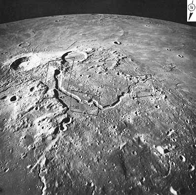 |
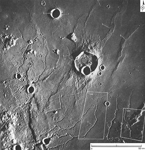
[180] FIGURE 185 [left].-This south looking oblique view, centered near 25.5° N, 50.5° W, depicts a prominent "cobra head" rille, Vallis Schroteri (Schroter's Valley). In the foreground is the Aristarchus plateau, and in the background the smooth surface of Oceanus Procellarum. The two large craters in the middleground are Aristarchus (38 km diameter) on the left, and Herodotus (30 km diameter) on the right. At first look the sinuous, flat floored Schroter's Valley and the tightly meandering channel within bear a striking resemblance to river valleys on Earth, and some viewers of the Moon have thought that sinuous rilles were formed by flowing water. In detail, however, sinuous rilles differ from river valleys in many respects; for instance, Schroter's Valley becomes smaller toward its downstream end. They are much like an entirely different terrestrial feature-lava channels. (See fig. 189.) Most geologists think that Schroter's Valley is a channel through which lava flowed from the circular crater at the "head" of the rille to the lower elevation of Oceanus Procellarum, a distance of approximately 175 km. Figures 186 to 188 are enlargements of the four sided areas outlined in this photograph.-M.C.M. |
|
[181] |
|
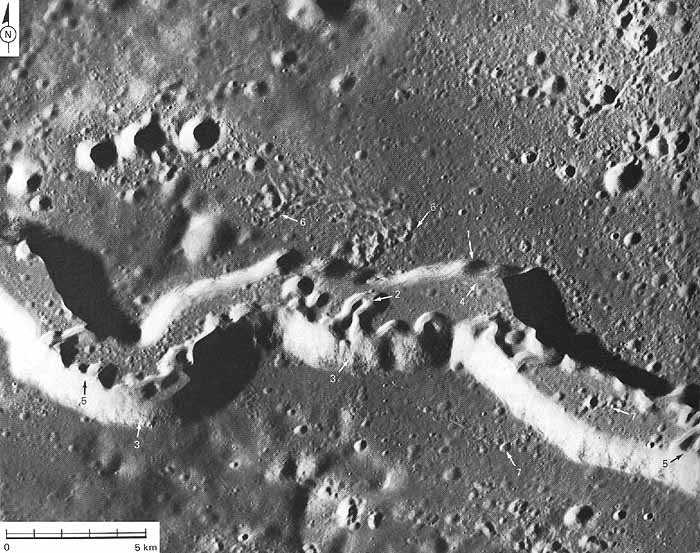
FIGURE 186 [above].-Schroter's Valley in the Aristarchus plateau is one of the largest lunar sinuous rilles (width in picture is about 5 km). The valley consists of an arcuate rille (1) that contains a meandering sinuous rille (2). The valley here traverses what appears to be a lava plain embaying low hills in the southern part of the picture. The blocky outcrop ledges, probably lava layers, near the rim (3) and the blocks at the inside base of the slopes (4) are of interest as is the downslope movement of material in the walls, which results in partial burial of the inside rille (5) and shows that the valley is laterally enlarged by mass wasting processes.
The sinuous shape, uniform width, presence of low levees, irregular depressions at the head of this and other rilles (outside the picture), and uniform cratering of floor and surrounding terrain suggest that the feature originated as lava flow channels, or collapsed lava tubes (Greeley, 1971). The rilles in the picture probably formed by the draining of a large lava flow channel and a smaller channel in a somewhat later flow that was confined within the boundaries of the larger channel. Incision by thermal erosion of lava streams with turbulent flow is an alternative explanation for the formation of sinuous rilles such as Schroter's Valley (Hulme, 1973).
Other conspicuous features in the pictures are secondary crater clusters from the young crater Aristarchus (6). The secondary clusters cross the rille at (7), and show that the crater Aristarchus is younger than the rille.-B.K.L.
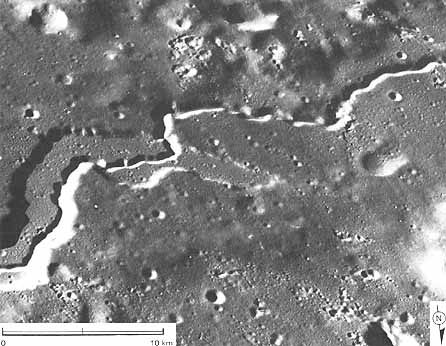
FIGURE 187 [above].- A view near the mouth of Schroter's Valley. Clearly shown are the old broad valley stage of formation of the valley-largely controlled by faulting-and the fresher, younger, meandering inner valley that probably represents a basaltic lava channel. Rocks returned by Apollo 15 from the banks of a similar channel are layered flows of vesicular (full of gas bubble holes) basalts. The valley drops 1600 m along its length a slope similar to terrestrial lava channels. Secondary craters from the bright fresh impact crater to the east show that the impact crater is younger than the valley. The valley like all terrestrial and lunar lava channels-gels narrower and shallower downstream, possibly reflecting the cooling of the lava and its loss of mobility as it gets farther from its source .-H.M.
|
|
[182] FIGURE 188 [left].-The pile of volcanic rocks that surround the crater at the head of Schroter's Valley has been called the Cobra Head. The crater is 40 km in diameter, the pile of volcanic rocks is 100 km in diameter. The abundant secondary craters on the volcano and the channel show that the crater Aristarchus, from which they were thrown, is younger than Schroter's Valley. The straight line segments of the valley that turn at sharp angles show that the basic form of the valley has been made by faulting, or breaks, in the lunar crust. The sinuous, meandering valley indicates that the basic straight valley shape has been modified heavily by later lava flows coursing down the valley. Samples returned by Apollo 15 from the side of a similar valley, Rima Hadley, strongly indicate that the rocks in the valley walls are basaltic lava flows. The rocks are layered because of the flow and have many holes (vesicles) formed by gas escaping from the rocks when they were still molten.-H.M.
|
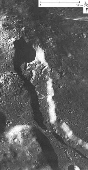
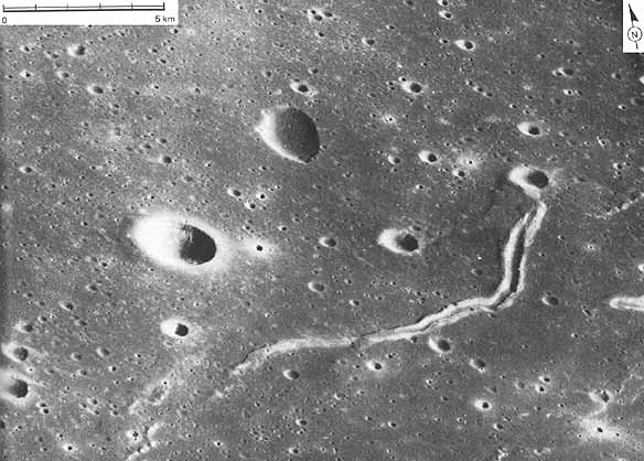
FIGURE 190 [below].-Pictured here is a lunar sinuous rille located in the eastern part of Mare Serenitatis. It is interpreted to be a lava channel because it resembles terrestrial lava channels like the one in figure 189. The rille starts in a crater (presumably the volcanic source) and follows a sinuous course downhill. The channel edges are marked by low ridges resembling those that form on actively flowing lava channels on Earth; the terrestrial ridges are formed when the outer edges of the molten lava chill and make natural levees. The lower reaches of the channel may be a lava tube that formed when the upper surface of the flowing lava chilled and froze while the hotter lava in the interior continued to flow. On the other hand, this ridge at the end of the channel may be a fracture along which lava has been extruded. Similar features are called "squeeze ups" in terrestrial lava flows. A possible small lateral lava flow is visible near the end of the feature.-H.M.
|
[183] |
 |
|
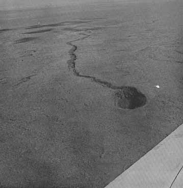
FIGURE 189 [right].-This volcanic crater and lava channel are near Craters of the Moon National Monument in southeastern Idaho. The resemblance to lunar "cobra head" rilles (like the one in fig. 188) is immediately apparent. The crater lies in the gently sloping Snake River Plain, a broad expanse of volcanic rock with craters and linear and sinuous features thought to have formed in the same manner as their lunar counterparts. Apollo astronauts studied this area in preparation for lunar missions. The crater pictured is approximately 100 m in diameter, and the associated channel is over 5 km long.-M.C.M. |
 |
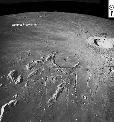 |
[184] FIGURE 191 [left].-The sinuous rilles in this photograph, east of the Aristarchus Plateau, are a particularly interesting complex of these unusual features for which no entirely convincing terrestrial analogs have yet been recognized. The rilles are at least partly controlled by fracture and most originate in craters. Rille A, beginning on the flank of the crater Prinz, appears to have had a distinct two cycle history, producing crater in crater and rille in rille structures. Rille B crosses a ridge of highland material without deviation or deformation, suggesting that the feature was superposed-that is, let down-from an earlier higher mare surface; the ridge appears to have been eroded. A shallow narrow rille (not visible in this photograph) occurs within the broader valley of rille C and is traceable across the elongate collapsed depression that bisects the main rille. Craters at the heads of rilles probably represent source vents for fluids that either eroded the rilles or formed lava tubes that drained, contributing to the volume of mare lava in Oceanus Procellarum. Ejecta from the young crater Aristarchus forms lightcolored streaks or "rays" across the dark mare surface; the high albedo of the rays may be due in large part to disruption of the surface by secondary craters.-C.A.H. |
FIGURE 192 [below].-A low Sun angle, larger scale view of part of the area shown in figure 191. Rima Prinz I (1) graphically displays many of the features considered to be indicative of lunar basaltic lava channels. The rille starts in a crater on the side of the ancient crater Prinz (just off the photograph) and descends about 300 m, becoming narrower and shallower downslope. It is a "two story" channel with a broader older channel and crater inside of which is a younger, more sinuous, channel with its source vent. Samples returned by Apollo 15 from the very similar looking Rima Hadley were from a vesicular (full of holes formed by gas bubbles) flow of layered basalt. The next channel to the west (2) also gets narrower and shallower downslope. It is the best example of distributaries-that is, a branching network of smaller channels at the downstream end of a larger channel.
Krieger (3) is a "Gambart type" crater inferred to be volcanic in origin. Its flat floor, irregular shape, and highly irregular external deposits resemble the crater Gambart south of Copernicus, which was studied in 1967 by Apollo 17 astronaut H. H. Schmitt. The deposits from Krieger lie on the surface of the mare basalts, indicating that the crater is quite young. Its youthfulness is confirmed by the freshness of the crater floor deposits and the characteristic shape of these deposits. A nice example of a sinuous rille, interpreted as a lava channel (4), runs out of the crater onto the mare surface. This lava surface is marked by wrinkle ridges (5)- complex mare ridges, generally asymmetric, with a braided ridge along one edge. These ridges are interpreted to be faults or breaks in the mare lava flows along which a later generation of molten lava has been both intruded, raising the already cooled mare lava flows, and extruded onto the mare surface.
A small (8 km diameter), young impact crater (6) is excavated into the mare material. The continuous ejecta blanket formed by the base surge-turbulently flowing ejecta riding on the surface-is particularly well shown. It forms a typical dune pattern (7); the crest to crest distance (200 m) is an index of the velocity of flow of the base surge. Similar dune lava features have been seen forming around terrestrial experimental craters.-H.M.
|
[185] |
 |
|
[186] |
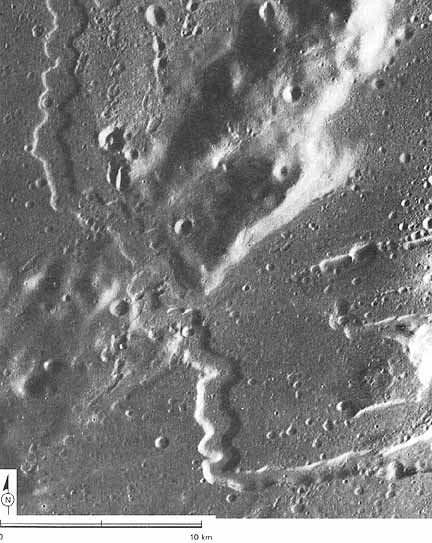 |
FIGURE 193 [above].-A larger scale view of part of the area of figure 192 shows the bend in Rima Prinz 11. It and Rima Prinz I form subparallel linear depressions that originate in small craters on the north flank of the crater Prinz. Both make right angle bends about 1/4 to 1/3 of the way from their source. The maximum width of the part of Rima Prinz II shown in this photograph is about 1.5 km. It is at least 100 m deep in the dark mare materials, and shallower in the rugged and older circumbasin (terra) materials. The rille is normal to the terra ridge where it cuts across the ridge, and is younger than the youngest materials it incises.
The processes by which lunar rilles form are open to controversy. Their sinuosities lack the characteristics of meanders in most terrestrial streams. The rims along the north portion of Rima Prinz II have both a rectilinear zigzag pattern and subdued arcuate sinuosity. In general, a concave reentrant is opposite a protruding wall. The rille floor displays the same crater density and the same crater size distribution as the mare materials adjacent to the rim. The morphological evidence, therefore, suggests that tensional stresses in the lunar crust probably caused the rille floor to subside between the steep normal faults that form the rille walls. The zigzag pattern of the walls probably is caused by irregular faulting along conjugate joints and fractures in the lunar grid.-M.J.G.
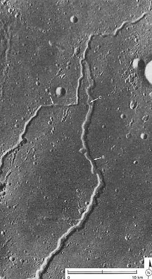
[187] FIGURE 194 [below].-The sinuous rilles here are part of a network controlled to some degree by fractures. In an area view (fig. 192) it may be seen that the east west segment at A parallels prominent linear trends of several rilles northeast of the Aristarchus Plateau. Fracturing alone, however, cannot explain the origin of the rilles. As shown by the larger rille (B), material has clearly been removed from the walls so that, despite their parallelism, they cannot be fitted together. In addition, a terrace occurs at C, suggesting two cycles of rille formation. The larger rille is nearly obliterated at its juncture with rille A, suggesting that formation of A may have been slightly later, and that some sort of fluid erosion and overbank flooding may have been involved.-C.A.H.
| Next |